

This presentation examines the orientations of the elliptical basins formed by oblique secondary impacts of glacier ice ejected by one or more extraterrestrial impacts on the Laurentide Ice Sheet. The impacts triggered the Younger Dryas cooling event, the extinction of the North American megafauna and the disappearance of the Clovis culture. We will try to determine if the basins were created not by one, but by multiple extraterrestrial impacts.
Subscribers to this channel are already familiar with the Glacier Ice Impact Hypothesis, which proposes that an extraterrestrial impact on the Laurentide Ice Sheet by the Great Lakes ejected pieces of ice in ballistic trajectories. The secondary impacts of the glacier ice boulders produced inclined conical cavities with raised rims that were transformed into shallow elliptical basins by viscous relaxation.
One of my recent videos showed that some impact basins in North Carolina are aligned to Lake Michigan, rather than to Saginaw Bay. For this reason, I selected several impact basins from different geographic locations to try to determine the convergence points of their major axes, but first, I am going to review several publications by diverse authors to see what they have to say on this topic.
A book published in 2006 by Richard Firestone, Allen West, and Simon Warwick-Smith proposed that a cosmic chain of events culminated in the extinction of the megafauna and the Clovis culture approximately 13,000 years ago. This book established what was later called the Younger Dryas Impact Hypothesis. These authors write: "By combining our own bay alignment research with that of Prouty, D. Johnson, Eyton, and Parkhurst, we have the compass headings of more than 1,000 large bays, and when we map the resulting lines, a clear and surprising picture emerges. Most of the lines meet in Wisconsin west of Lake Michigan. Other lines point farther north into Canada." The authors mention that they used some of the previous research by Prouty, Johnson, Eyton and Parkhurst.
We start chronologically with the book published by Douglas Johnson in 1942 titled "The origin of the Carolina Bays". The main objective of Johnson's book was to promote his hypothesis of complex origin, which postulated that the Carolina Bays originated from pools made by artesian springs, which were then modified by wind and water mechanisms. Johnson's book also tried to provide evidence against the meteoritic hypothesis proposed in 1933 by Melton and Schriever which relied on the parallel alignment of the Carolina Bays.
Johnson was only interested in showing that the directions of the Carolina Bays were not parallel in order to prove that Melton and Schriever's meteoritic theory was wrong. He did not attempt to find a convergence point for the bays because he believed that their orientation was determined by the prevailing winds. The axial directions given by Johnson are relative to the south. For example, 30 degrees east of south corresponds to a heading of 150 degrees. Throughout his book, Johnson refers to the Carolina Bays as oval, rather than elliptical and he did not do a systematic analysis of the alignments.
Firestone's book mentions alignment research by William Prouty, who published a paper in 1952 titled Carolina Bays and their Origin. Prouty supported the impact origin of the Carolina Bays, but he thought that the shock waves of meteorite impacts contributed to the elliptical geometry of the bays. Prouty's statistical studies of orientation show a grater divergence of smaller bays from the mean than larger bays.
Figure 13 in Prouty's paper illustrates multiple bays in Atkinson County, Georgia. The caption says: Largest of the four multiple bays in this area is about 3 miles long and composed of four separate, overlapping elliptical depressions. Directly south of the large bay is a multiple bay of medium size composed also of 4 overlapping elliptical depressions. To the west are two smaller multiple bays, each with two overlapping elliptical parts. In each bay, the unit or units to the west have a smaller azimuth of orientation of the long axes than do the units on the east side. I was very interested in the alignment of these Carolina Bays because the different orientations provide evidence of projectiles coming from the north and from the northwest, which would add support for multiple extraterrestrial impact sites by the Great Lakes.
I looked at the LiDAR image of Atkinson County in Georgia to try to find the Carolina Bays mentioned by Prouty. The city of Pearson is in the center of the county. Willacochee is on the left boundary of the county and Axson is on the right boundary of the county. I was not able to find the overlapping bays illustrated by Prouty. There are some Carolina Bays, but nothing that resembles Prouty's drawing.
I tried using the roads in the photographs of the photo mosaic to locate the Carolina Bays, but when I found the roads there were no such bays. Prouty does not give the coordinates of these features and it is impossible to verify his observations about the alignments. The photographs have a date of December 6, 1938. Eighty four years have passed since the photographs were taken. Atkinson county is 80 miles from the Atlantic Ocean and 100 miles from the Gulf of Mexico. It is possible that the bays illustrated by Prouty have been destroyed by erosion from storms and hurricanes during the past 84 years.
The book by Firestone also mentions the alignment research by Eyton and Parkhurst, who wrote a paper in 1975 titled "A re-evaluation of the extraterrestrial origin of the Carolina Bays". In their paper, these authors propose that airbursts of pieces of a disintegrating comet created the Carolina Bays.
Eyton and Parkhurst provide a map with the orientations of the Carolina Bays. The authors measured the azimuths of 358 bays from fourteen counties from Georgia to Virginia. The graph shows the orientation of the mean values in these fourteen counties. Eyton and Parkhurst avoided some work by using the mean azimuths for the fourteen sample counties along the Atlantic Coast instead of plotting the 358 individual impact basins. Their map shows only 14 lines, which according to the authors display radial alignment with an apparent focus in either southern Ohio or Indiana.
Firestone extends the lines for the alignments provided by Eyton and Parkhurst using great circle paths to go beyond Ohio and Indiana toward Wisconsin and into Canada.
One of the reasons why Eyton and Parkhurst found a focus in either southern Ohio or Indiana is because they drew straight lines on a flat map instead of using great circle paths. The image on the right shows a Carolina Bay whose major axis has a heading of 128.4 degrees. There is significant angular difference on the flat map when the heading is extended toward Wisconsin as a great circle path, which is the shortest path between two locations on the surface of a globe. The use of Google Earth simplifies drawing the great circle paths.
In 2010, Davias and Gilbride presented a paper that correlated an impact structure with the Carolina Bays. Using an initial field of 40 Carolina Bays they generated great circle paths for visualization in Google Earth. This yielded a fuzzy triangulation point centered at 43.5 degrees north, and 89.5 degrees west in Wisconsin.
This location coincides with what Firestone reported. Davias selected Saginaw Bay instead of Lake Michigan for further analysis and went on to establish a LiDAR visualization tool for Google Earth that contains locations of more than 50,000 Carolina Bays. You can find a link to this tool in the description of the video.
Although the convergence point of the Carolina Bays is over Wisconsin, Firestone says that the comet did not land in Wisconsin. A point on the surface of the ground in Wisconsin would be moving from west to east at a remarkable 700 miles per hour, faster than a jet and about as fast as a bullet. The motion is great enough to create an illusion, distorting the flight path to make it seem that it started further to the west. According to Firestone, the actual impact site was in or over Lake Michigan.
Firestone drew two rough ellipses on Lake Michigan and suggested that these are the locations of the meteorite impacts. The areas selected by Firestone correspond to the deepest points of Lake Michigan. The Chippewa Basin, which is the deepest part of Lake Michigan, is 282 meters or 925 feet deep. The lake bed extends below sea level.
Getting the alignment of the Carolina Bays and other impact basins is a laborious task. The orientation of each basin may differ from that of its neighbors. However, using the mean values suppresses the information that can be obtained from the outliers. If you have a tub with 98 apples and two oranges, you cannot treat it as if it contained only apples and the oranges did not exist. Similarly, although the genetic difference between humans and chimpanzees is only 1.2%, you cannot say that the difference is negligible and lump both together in one category.
Here is a sample of twenty Carolina Bays for which I obtained great circle paths. I labeled them using their coordinates or the identifiers provided by Michael Davias in his LiDAR visualization tool. I tried to find basins with well-defined rims that were not greatly distorted by erosion or soil movement. I then used Google Earth to get the heading and extended a line toward the Great Lakes while maintaining the same heading. It is very easy to make errors in the headings for bays that are distorted, eroded or almost circular.
This Carolina Bay in the Delmarva peninsula is almost circular. It illustrates the difficulty of determining the heading. The rim on the northwest is not very clear and the drainage channel on the west side has caused a slight westward shift of the terrain. Also, the southeast rim of the bay has been degraded by a road. The rim is still visible on the east side of the road, but it is not as well defined as on the northeast side of the bay. To get the heading, we start by trying to get the best fit of an ellipse just inside the rim of the basin. This corresponds to the cavity made by the ice boulder impact.
The graphic tool for the ellipse provides guidance for determining the angle of the heading. The red circles highlight the points of the ellipse used for the heading. The heading is a vector that indicates the direction of the projectile that made the impact basin. In this case, the heading is 123 degrees and not 303 degrees, as indicated in some of the older literature. These headings differ by 180 degrees and it makes a difference. Going from Chicago to Washington is not the same as going from Washington to Chicago.
In some areas, like Alabama, there are not many Carolina Bays and even the best ones are not very suitable for determining the headings. A wider view of the same area in Alabama shows that the terrain is highly eroded and the choice of Carolina Bays for determining the headings is very limited.
Some regions, like New Jersey, have dense concentrations of Carolina Bays, but it is virtually impossible to determine the direction from which the impacts were made because all the bays are small, mostly circular and distorted by terrain movement. Any headings calculated for this area are not very reliable.
The best impact basins for determining the heading have elliptical geometry and well-defined rims, but even in these cases the heading may vary by a small angle, which can result in substantial deviations for distances of 1,500 kilometers. The great circle paths forming the extensions of the major axes of the impact basins intersect at various points on the map. In this particular sample, the lines from Nebraska, North Carolina and Virginia intersect near Lake Michigan. The lines from Kansas, Oklahoma, Georgia and South Carolina intersect closer to Saginaw Bay.
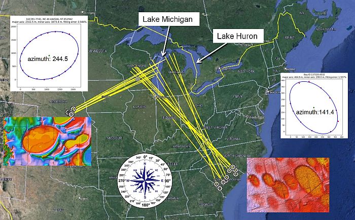
The greatest number of lines intersect by Lake Michigan at the latitude of Chippewa Basin. Another intersection is at the latitude of the South Chippewa Basin in Lake Michigan. Several lines intersect in Ohio, just west of Lake Erie, and Saginaw Bay also has some intersecting lines. All these could be potential impact sites of a disintegrating comet or asteroid.
However, to create the Carolina Bays from secondary impacts of glacier ice, the sites of the extraterrestrial impacts must have been covered by ice because any impacts on ice-free ground would have left a recognizable crater with evidence of shock metamorphism. Thus far, such a crater has not been found. The extent of the Laurentide Ice Sheet varied significantly during the Ice Age and some scientists have claimed that the ice sheet had retreated from the Michigan peninsula at the time of the purported impact 12,900 years ago. It will take much more effort to convince the critics that an extraterrestrial impact on the Laurentide Ice Sheet was responsible for the origin of the Carolina Bays.
